State-of-the-art equipment delivering precision and unparalleled accuracy.
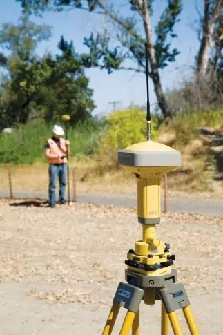
Topcon GR5 GNSS Receiver
The GR-5 features the multi-constellation 226-channel Vanguard GNSS chip with Universal Tracking Channel Technology. This patented technology uses flexible and dynamic tracking methods to automatically select and track any available satellite signal enabling Topcon’s users to receive the maximum number of signals and measurements at any given time. The GR-5 is not only capable of receiving signals from the fully operational GPS and GLONASS constellations, but also has the ability to support all planned signals from developing systems such as Galileo, Beidou (BDS) and QZSS. With current and developing satellite constellations, Universal Tracking Channel Technology optimizes GNSS signal tracking to guarantee maximum satellite geometry and availability.Topcon’s patented Fence Antenna design brings superior signal reception and advanced multipath rejection in difficult environments. This technology provides a more robust and cleaner signal tracking which means unparalleled results.With Vanguard Technology, Universal Tracking Channel and the Fence Antenna, the GR-5 is designed to deliver ultimate field performance even in challenging environments while maintaining unmatched accuracy, speed of initialization and fix reliability for RTK solutions.
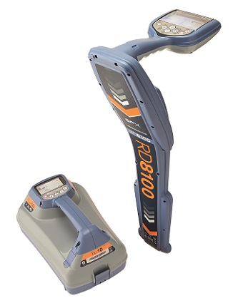
RD 8100 Pipe and Cable Locator by RD Palmer
With utility infrastructures becoming more complex, locate professionals require more powerful tools to simplify the task of distinguishing between and tracing different utilities. RD8100 is one of best pipe and cable locator in the market. It has number of features which increase its precision in utility detection. One of the features is Current Direction.It is a powerful tool that augments the capabilities of pipe and cable locators to help operators pick out their target line from others nearby. Using fundamental properties of electromagnetism, CD allows you to locate your utility quickly, and eliminate wasted time following false trails. Another great feature is Power Filters. It is used to distinguish and pin point between cables in the absence of power transmitter. When a signal transmitter can’t be connected, tracing individual underground power lines through complex networks can be a real challenge: conflicting or powerful signals can confuse the operator, or combine to create a broad signal. Power Filters function is able to establish if a signal comes from one source, or from multiple cables, then trace and mark their routes
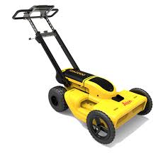
Leica DS2000 Ground Penetrating Radar (GPR)
Our company has invested in this technological advanced equipment to ensure accuracy and precision in our data delivery. This ground penetrating radar is capable of detecting all buried utilities including non-conductive pipes and fibre optics .It detects metallic and non-metallic utilities in deep and shallow depth simultaneously with the dual-frequency 250 Mhz and 700 Mhz antenna. Apart from that it has superior detection and precision positioning technology as compared to pipe cable locator which can only detect metallic materials.
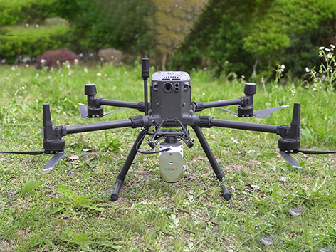
Airborne Lidar + RGB System (CHCNAV AlphaAir 450)
The AlphaAir 450 is designed for simplicity and precision, making advanced geospatial reality capture accessible to non-professional users and those new to the technology. At an affordable price, the AA450 combines ease-of-use with high-precision capabilities. This lightweight, durable solution integrates a high-performance laser scanner, a professional-grade 26 MP industrial camera, and a high-precision inertial navigation system to ensure superior data collection quality.
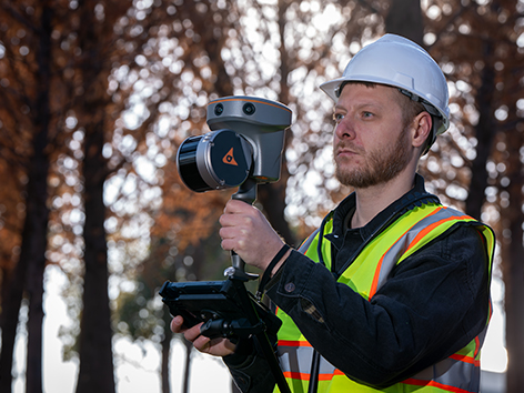
Handheld Slam 3D Laser Scanner (CHCNAV RS10)
The RS10 integrates GNSS RTK, laser scanning, and visual SLAM technologies into one single platform. This fusion increases the efficiency and accuracy of both indoor and outdoor 3D scanning and surveying tasks. It gives surveyors the ability to work in areas with weak GNSS signals, providing unparalleled flexibility. Designed for surveying, BIM, forestry, power line inspection, underground mapping, and more, the RS10 embodies versatility, making it an essential tool for professionals looking to expand their surveying capabilities.